


HochwassergefahrST
Опис програми HochwassergefahrST
The "HochwasserhazardST" app is used to inform the public about the risk of flooding in the state of Saxony-Anhalt. It also provides information on flood protection and what to do in the event of a flood. Since the app is for citizen information, it is free.
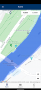
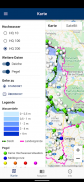
The flood risk maps of the state of Saxony-Anhalt are visualized in the map area with the "HochwasserhazardST" app. The classified water depths of areas that are flooded during a flood event are shown. The display can be selected for 3 defined scenarios with different probabilities of occurrence. In addition to the HQ100, which statistically occurs once every 100 years, the effects of the flood probabilities HQ10 and HQ200 can be illustrated. Accordingly, the areas do not show any past events, but instead represent calculation results with a defined statistical probability of occurrence.
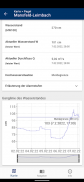
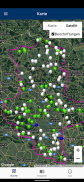
Within the map display, current water levels can be called up at the gauge location in the app by touching the gauge symbols. Further level information can alternatively be found on the website of the state's flood forecasting center. In the event of flooding, the level symbols are colored according to the alarm levels currently reached for the flood notification levels.
The flood protection dikes that are the responsibility of the state can also be displayed. Touching the dyke line opens the relevant master data for the respective dyke section. Either topographical maps or satellite images can be set as the background (base map).
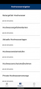
In the sidebar (sidebar), which can be shown and hidden using the menu symbol in the upper left corner, the presentation of the data offered (flood hazard map, dykes, gauges, location view, country view) can be switched on and off as well as the type of underlying base map (topographic map, satellite image) can be selected. The "Location view" and "Country view" buttons can be used to switch between the specific location of the user and the country overview. There is also a legend at the bottom of the sidebar that explains what is shown on the map. The sidebar is scrollable.
With the "HochwasserhazardST" app, important explanations on the subject of flood risk and the contents of the flood risk maps are given in the Advice section. In addition, you will find references to other sources of information on the current situation as well as explanations of the usual alarm and notification levels to support you in the event of a specific flood. In addition, a lot of information is provided on the subject of flood protection measures and precautions as part of personal precautions. All relevant terms are explained in the glossary. With a simple touch on the corresponding topic, the available content is displayed. In the sub-terms or topics there is a back button (arrow to the left) at the top left, which takes you back to the higher-level term or topic.
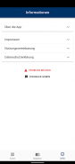
With the app "HochwasserhazardST" - in the information area - further information about the app is made available. In addition to user help and the legal conditions, you can also find ways to report feedback and errors to the developers and operators of this app.
Regional restriction: The "HochwasserhazardST" app only contains data from Saxony-Anhalt. Therefore, this app can only be used sensibly for the area of Saxony-Anhalt.
HochwassergefahrST – Версія 4.1
(22-04-2023)HochwassergefahrST - інформація про APK
Версія APK: 4.1ID пакета: de.geoapis.apps.hochwasserst

 4.34
4.34


 4.63
4.63
Додатки в цій категорії


Вам також може сподобатися...


